
Belleville Neighbors by Block
The immediate block is best read through several local sources. The county GIS shows which parcels touch. The Assessor provides tax-year details. City maps add ward or municipal context. Belleville associations explain how residents organize around shared concerns.
| Source | What It Shows About a Block | Access |
|---|---|---|
| County GIS parcel and road layers | Adjoining parcel IDs, roads, boundaries, legal and address fields | Free public map |
| Assessor address search | Parcels in a number range, owner, mailing and site distinctions | Free tax portal |
| Ward and city maps | Street segments and council context | City maps and code |
| Neighborhood Partnership | Zone, association, watch, leader or ambassador leads | Plan and current group pages |
| Historic maps and atlases | Past buildings, lots, uses and street shape | Digital or repository access |
| Permits and inspections | Dated work tied to a defined address | Department or FOIA request |
These records describe parcels, public roles, or events. None proves all present occupants. Belleville neighbors may own, lease, share, inherit, or manage a parcel, while the tax mailing address can point somewhere else.
Map Belleville Neighboring Parcels
The St. Clair County GIS Parcel Map Viewer accepts an address or parcel ID. A parcel click opens property attributes, while the parcel and roads layers show what touches the starting site. Municipality and township overlays prevent postal labels from being mistaken for city limits.
- Enter the known street address and confirm the selected parcel shape.
- Record its parcel number, site address, municipality, and tax year or layer year.
- Click only the parcels that directly border it or face it across the road.
- Compare owner and mailing fields with the Assessor, without calling either an occupant.
- For a whole named road, move to the Belleville street directory workflow.
This address to parcel to adjacent parcel flow keeps the research radius small. It also preserves the parcel number, the strongest bridge between GIS, the Assessor, and a Recorder index search.
Reading Belleville Block Records
The county parcel layer includes more than owner text. Site number, street prefix and suffix, unit, city, state, ZIP, legal description, subdivision, neighborhood code, land use, class, tax code, values, and several district names may appear. The record can also distinguish a site address from the tax-bill mailing address.
- Parcel
- A mapped unit of land identified by a county number.
- Site address
- The location assigned to the parcel, which can differ from the tax mailing address.
- Legal description
- The formal land wording used to identify the tract in recorded documents.
- Municipality
- The incorporated city field, which is not the same thing as a postal city label.
A published owner field still does not state who sleeps at the address. Values and classifications are tied to a given tax year. Record the year and field label exactly.
Belleville Deed Links by Parcel
When an adjacent parcel raises a title question, the parcel number can bridge to the Recorder. The free AVA index enables party, date, document number, document type, and parcel controls. Address, subdivision, tract, and book-page terms exist in its underlying field vocabulary, but current settings disable many of them. A visible technical label does not guarantee a live search.
The successful manifest capture below comes from the St. Clair County AVA settings source. It documents which controls are enabled.
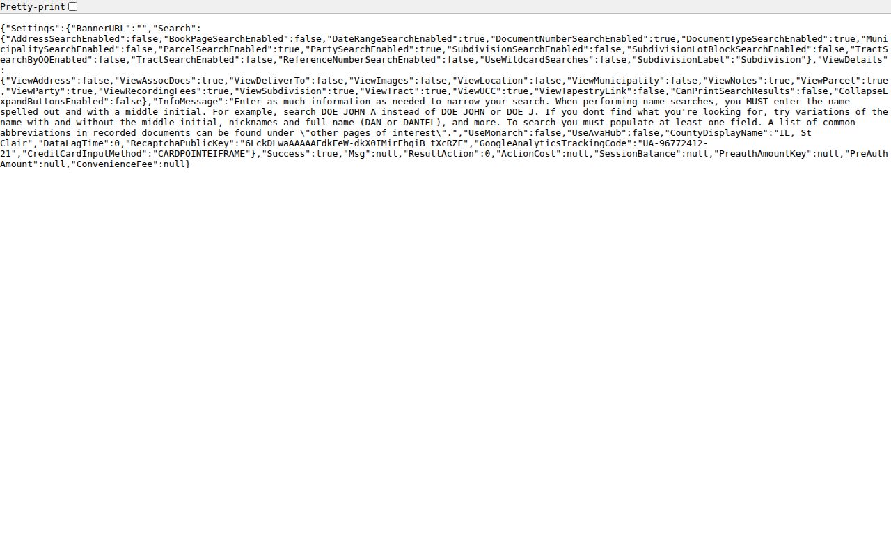
The settings explain why a parcel number is more reliable than trying an unsupported street field. A deed party can be a grantor, grantee, trustee, lender, or other role, not necessarily a neighbor.
Belleville Parcel Image Access
The Recorder separates free index access from image access. AVA supplies data without document images. Tapestry is a round-the-clock pay-as-you-go route listed at $8.75 for an index or image search and $1 per printed page in the research capture. Laredo offers subscription access. The Recorder also has public workstations and a copy request route.
The manifest's second Belleville neighbors image shows the official Tapestry EON login.
This paid official portal differs from a commercial neighbor finder. It returns county-designated land-record images, not an assembled personal profile. Verify current fees before ordering.
Belleville Neighborhood Associations
Belleville's adopted plan counted 27 active neighborhood associations in 13 zones. That is a plan-era inventory, not a guaranteed current roster. The city's partner-organizations handout describes zone leaders, ambassadors, and association or watch input. Current activity should be checked with each group.
Signal Hill
Signal Hill Neighborhood Association describes itself as an Illinois not-for-profit and publishes local events and news.
Ogles Watch
Ogles Watch says it began in 2013 and covers the Ogles area in Belleville and Stookey Township.
Neighborhood Partnership
Community Development is the fallback when a current contact cannot be verified from a group's own page.
Other plan-era names include Hexenbuckel, Franklin, Westhaven, Powder Creek, Harmony, Lincoln Circle, Meadowdale Heights, and Brookhill Estates. They are civic leads, not resident rolls or proof of membership.
Belleville's 13 Civic Zones
The count of 27 associations across 13 zones is useful because it shows that Belleville community geography does not fit one simple neighborhood layer. Associations, watches, homeowner groups, wards, townships, and postal labels can overlap. The numbers also explain why a citywide current contact list is hard to maintain.
Use the group name and its own current page where one exists. If a plan-era association has no active page, ask Community Development for the current route. Do not assume that every parcel within a historic zone belongs to a group or that every nearby resident is a member.
Note: Association boundaries describe civic organization and shared issues; county parcel lines remain the correct source for land adjacency.
Belleville Neighbors Across Time
The 1884 Library of Congress Sanborn set contains 14 sheets for Belleville. It can show historic street layout, building footprints, business names, and land use. The St. Clair County Historical Society also holds atlases from 1874, 1901, 1936, and 1956. Pairing one old sheet with modern GIS creates a careful then-and-now block comparison.
A map does not identify every occupant. Printed city directories and newspapers must supply names for a specific year, while a deed supplies a title event. Preserve old street spelling and numbers because renumbering or edition gaps can break a modern search. The Belleville Public Library and Historical Society are the fallback when an image is not online.
Belleville Block Changes by Request
The 2026 city building permit form records a construction address, parcel number, subdivision, lot, zoning district, applicant, owner, type of work, existing and proposed use, and project contacts. Those fields can tie a dated change to one site. They do not establish that an applicant or owner lives there.
No public Belleville permit-case index was located. Request a defined address, date range, or project from the relevant department or through the Belleville City Clerk FOIA route. The Fire Department reports more than 2,000 inspections a year within corporate limits, but no public inspection database was found. A narrow request is the documented access channel.
Belleville Neighbor Source Choices
Official parcel tools and commercial neighbor categories answer different questions. County records show a dated legal or tax fact. Community organizations publish only what they choose for civic participation. Commercial tools may blend stale data from several sources and obscure the date or role.
| Source Type | Strength | Limit |
|---|---|---|
| GIS and Assessor | Parcel key, site, owner, mailing, district context | Not proof of occupancy |
| Recorder index and image | Dated instrument and party role | Title event, not household roster |
| Association page | Current civic news and contact route | Voluntary and incomplete |
| Commercial category | May offer a quick lead | Source, date, and accuracy may be unclear |
Prefer the source that actually owns the record. Keep its date, key, and limits attached to every claim.
Privacy for Belleville Neighbors
Illinois law can shield personal data through FOIA exemptions, sealed records, voter restrictions, and the Address Confidentiality Program. That program lets eligible survivors use a substitute address for new agency records and protect voter information. Earlier public land records may remain, but a protected value should never be traced back to an underlying location.
Utility accounts, delivery data, private group rosters, and unlisted household members are not public block rolls. Keep a block search focused on parcels, public events, civic contacts, and the minimum information needed.
Lawful use. Research Belleville neighbors for civic context, local history, reconnection, or personal safety. Never use block records to watch, stalk, harass, intimidate, or harm a person.
The safe result is a sourced description of the block. It is not a compiled list of private occupants.