
Walk a Belleville Street Directory
A street search works best as a chain of dated records. Start with a complete Belleville address, including its direction and ZIP, then use the county tax roll to find the parcel. The tax record identifies an owner for a stated year, not everyone at the site. County GIS adds parcel shape and boundary context. A deed supplies named parties and a legal description. An authorized voter check or dated directory can add evidence about a person at the address, but neither should be stretched beyond its purpose.
- Normalize the delivery form with USPS, while preserving the address exactly as first found.
- Search the St. Clair County Assessor portal by street and house-number range.
- Open the parcel in the county GIS viewer and inspect nearby lots and boundaries.
- Carry the parcel number or owner into the Recorder's AVA index, then obtain the deed when needed.
- Use an authorized voter check for current status and a criss-cross directory for a dated household clue.
This process separates ownership, postal routing, and occupancy. It also leaves a trail another researcher can repeat. For one named person rather than a full road, use the Belleville resident lookup.
Belleville Streets in DEVNET
DEVNET wEdge is the most direct official base for a Belleville street directory made from parcels. Address Search accepts a number range, so one query can return the assessed sites along a block or named street. Results may be exported to CSV. Each parcel card stays tied to a tax year, and the portal warns against reading the data outside its intended use.
| Field | Input | Street use |
|---|---|---|
| House Number Low | Optional number | Start a block range |
| House Number High | Optional number | End a block range |
| Street Name | Optional text | Search one named road |
| City | Optional text | Limit postal-city matches |
| Basic Search | Parcel or owner | Open one known record |
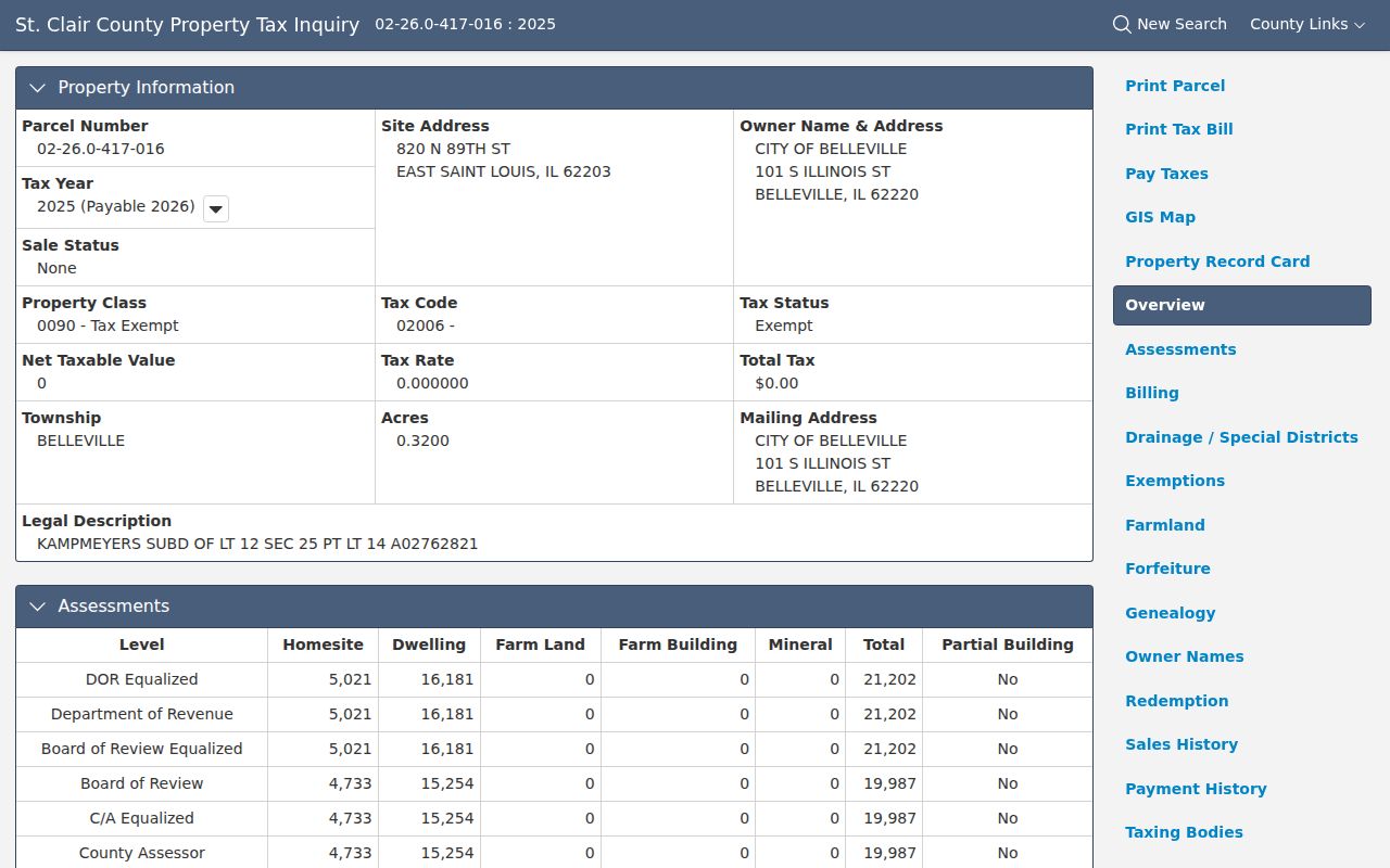
A card can show the site, owner mailing address, parcel number, township, class, value, legal description, year links, and GIS button. Those fields can point to different places. The official sample parcel detail shows that distinction.
Three Belleville Address Labels
A City of Belleville sample search produced a tax-exempt parcel with a site in East St. Louis, an owner mailing address in Belleville, and a Belleville township field. The card shows why mailing city, site city, and township cannot become one residency claim. Record each value with its exact label.
The parcel number, legal description, tax year, and municipality layer are stronger cross-system keys than the mailing line. This local example turns a common street-directory error into a rule: say which field was found and what the keeper uses it for.
Key distinction. A tax-bill address tells the county where to send mail; it does not identify an occupant at the parcel.
Map Belleville Streets in GIS
The GIS viewer accepts an address or parcel ID and lets a researcher click a mapped lot. Its parcel layer includes site-address parts, ZIP, owner and mailing fields, legal description, district names, and neighborhood codes. Roads, municipalities, townships, the county boundary, railroads, and highways provide needed context. Drawing and measuring tools can define a block without turning nearby owner fields into an occupant list.
Use GIS after DEVNET, not instead of it. The tax card provides a year-specific record, while the map gives spatial context. If two lots have similar addresses, compare parcel IDs and legal descriptions. Split lots, shared descriptions, or different municipality fields can make results look duplicated when they are not.
Belleville adds several civic layers to that map check. The city has eight wards whose legal boundaries often follow named streets, while county parcels also carry township and tax-district fields. A road such as Main, Illinois, Douglas, Washington, Lincoln, or State can appear in more than one civic context. Save the directional prefix, house number, municipality field, and township rather than copying only the street name. Historic district labels can shift too. Old Belleville, Hexenbuckel, and Oakland were recognized at different dates, so a neighborhood name in a later plan should not be projected backward onto an older directory entry. GIS helps locate the modern parcel, but the record from the target year controls the historical statement.
Belleville Records Indexed by Street
No Belleville street directory proves every person at every door. Each source answers a smaller question, and access ranges from a free portal to a written request.
| Record | Keeper | Evidence | Access |
|---|---|---|---|
| Assessment roll | County Assessor | Owner, site, mailing, class, tax year | DEVNET or office |
| Parcel map | County GIS | Geometry, roads, municipality, districts | Web viewer or GIS office |
| Recorded instruments | Recorder of Deeds | Parties, date, parcel, legal description | AVA, paid images, workstations, copies |
| Voter verification | State Board of Elections | Authorized current registration check | Individual lookup; restricted file route |
| Permits | City of Belleville | Dated project and parcel fields | Department or FOIA request |
| Historic streets | Public Library | Householders opposite street numbers | Digital, visit, mail, email, staff lookup |
The Assessor and Recorder are at 10 Public Square. The Recorder offers seven free public search workstations on business days. Library Archives accepts a specific-index request online, by email, in person, or by mail.
Belleville Deeds Along a Street
The Recorder AVA search is free and index-only. It enables party, date-range, document-type, document-number, and parcel searches. Address, municipality, book/page, subdivision, tract, and wildcard searches were disabled in the inspected settings. The parcel number from DEVNET is therefore the best bridge from address to deed index.
The Recorder access page gives every next route. Tapestry is a 24-hour pay-as-you-go image service. Laredo is subscription access. Office workstations are free. Staff explain the index. Email or phone serves requests under ten non-certified pages; certified or larger requests go by mail with payment. Most remote images are described as January 1986 forward, while the public record series reaches the late 1790s.
The office reports roughly 300 documents recorded each day. A result may name a grantor, grantee, lender, trustee, company, or lien claimant, so a name in AVA is not an occupancy fact.
Belleville Street Record Terms
Four labels prevent major errors when the street directory crosses tax, map, and deed systems.
- Parcel
- A mapped unit of land with a county identification number.
- Situs address
- The physical site, which can differ from the owner's mailing address.
- Plat
- A recorded map dividing land into lots, blocks, streets, or easements.
- Criss-cross directory
- A directory ordered by street and number instead of only by surname.
Keep formatted and unformatted parcel numbers when both appear. Preserve the tax year too. A change between yearly parcel cards may be more useful than the newest screen alone.
Belleville Permits by Address
The city's 2026 building-permit application records applicant and owner details, proposed construction address, permanent parcel number, subdivision, lot, zoning district, work type, and existing or proposed use. Those fields can date a change. They do not establish that an applicant, contractor, or owner lived there.
No public permit or code-case index was found. Request a defined address, date range, and project through the department or Belleville City Clerk FOIA route. Fire officials report more than 2,000 inspections a year within city limits, but no public inspection search was located. A missing online search does not mean no record exists.
Historic Belleville Street Numbers
The official 1925 and 1935 volumes include street directories arranged alphabetically by road and numerically by house number, with householders or concerns opposite. Earlier and later city directories extend the trail. The Belleville city directory collection covers those runs in depth.
The 1884 Sanborn set has 14 sheets, while the Historical Society holds atlases from 1874, 1901, 1936, and 1956. Maps show lots, buildings, streets, and use, not every occupant. No authoritative citywide street-renaming or number-conversion table was found. Preserve the printed form and ask the library, City Clerk, or GIS office about a specific block.
Belleville Public Library Archives is on the second floor at 121 E. Washington Street. Staff provide a specific-index lookup rather than broad family research. Requests can be made online, by email, in person, or by mail, and the listed lookup rate is $2.50 per name or record. The St. Clair County Historical Society's research library at 705 E. Washington Street adds the atlas and directory shelf. Its listed weekday hours are 10 a.m. to 2 p.m., excluding holidays. Confirm hours and charges before visiting.
Verify a Belleville Street ZIP
Postal geography can mislead a by-address search. Belleville-associated codes include 62220, 62221, 62222, 62223, and 62226, while older lists contain more nearby codes. USPS routing does not draw the city boundary.
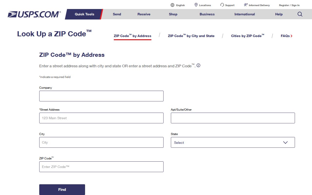
Use the USPS ZIP Code Lookup for a current delivery line and ZIP+4, then compare the GIS municipality field.
Limits of Belleville Street Directories
Property records identify assessed owners and deed parties, not a complete household. An individual voter lookup is an exact verification tool, not a public roster. State voter files have narrow purpose rules and redact sensitive details. A permit may name an owner, applicant, or contractor without proving occupancy. Historic maps show structures; directories offer a dated printed clue that still needs support.
Absence may be deliberate. Illinois's Address Confidentiality Program substitutes an address for eligible participants, and other rules may withhold data. Never fill a blank with a guess. Record the source, year, fields, and access limit.
Lawful use. Belleville address records support lawful personal, family, property, and civic research. Never use them to stalk, harass, threaten, or expose a protected address.